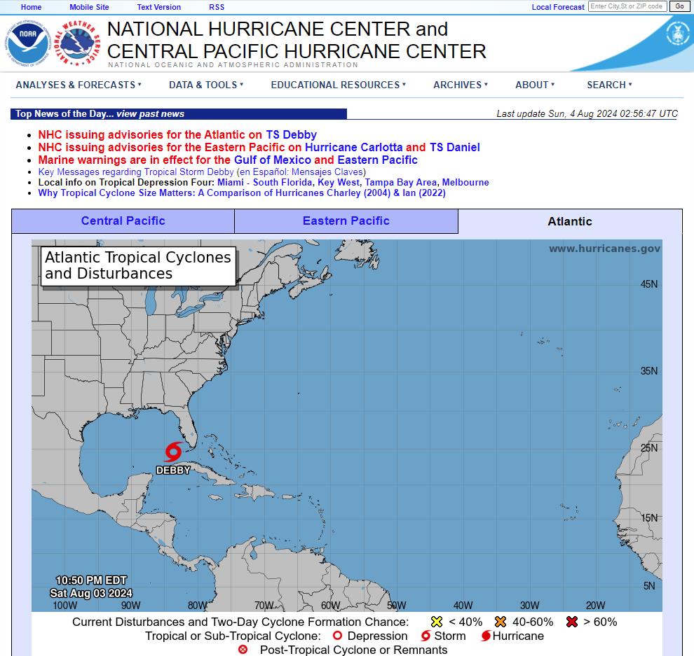
…DEPRESSION BECOMES TROPICAL STORM DEBBY OVER THE SOUTHEASTERN GULF OF MEXICO… …HURRICANE WARNINGS ISSUED FOR PORTIONS OF THE GULF COAST OF FLORIDA…
Tropical Storm Debby Discussion Number 6
NWS National Hurricane Center Miami FL AL042024
500 PM EDT Sat Aug 03 2024
The tropical cyclone has become better organized since the last
advisory, with the circulation center becoming better defined over
the southeastern Gulf of Mexico and areas of outer convective
banding to the north and south of the central region. A
combination of earlier scatterometer data, surface observations in
the Florida Keys, and ship reports in the Straits of Florida shows
an area of 30-35 kt winds located about 120 n mi from the center in
the eastern semicircle. Based on this information, Tropical
Depression Four is upgraded to Tropical Storm Debby.
The initial motion is now northwest or 310/13 kt. A large mid- to
upper-level trough over the central United States is creating a
break in the subtropical ridge, and Debby is expected to turn
northward into this break in about 24 h. This should be followed
by a gradual turn toward the northeast at a slower forward speed
through 60 h. This motion should bring the center near or over the
northern Gulf coast in roughly 48 h. After landfall, weakening
steering currents should cause the cyclone to slow down while it
moves northeastward or eastward over parts of northern Florida and
Georgia. The uncertainty in the forecast increases significantly
after 60 h as the cyclone interacts with a portion of the U.S.
trough. The latest GFS and ECMWF models show a slow eastward
motion into the Atlantic, followed by a turn toward the north or
northwest that brings the center back inland. On the other hand,
the Canadian model is still forecasting Debby to move slowly
northeastward across the southeastern states and does not bring it
over the Atlantic. This portion of the new forecast track
continues to show a slow motion and leans toward the GFS/ECMWF
solutions.
Conditions are favorable for strengthening over the Gulf of Mexico
with warm sea surface temperatures and light shear.
Intensification is likely to be slow during the first 12-24 h, then
proceed at a faster rate after the cyclone develops an organized
inner core. The new intensity forecast calls for a peak intensity
of 65 kt at landfall on the Gulf coast of Florida in best agreement
with the HWRF model. Weakening is forecast after landfall while the
system moves over the southeastern United States. Beyond 72 h, the
intensity forecast remains quite uncertain due to the possibility
of land interaction and how much interaction will occur with the
aforementioned mid-latitude trough.
Key Messages:
1. Heavy rainfall will likely result in considerable flash and urban
flooding across portions of Florida and the coastal areas of the
Southeast this weekend through Thursday. Significant river flooding
is also expected.
2. Hurricane conditions are expected on Monday along portions of
the Florida Big Bend region where a Hurricane Warning is in effect,
with tropical storm conditions beginning late Sunday. Tropical storm
conditions are expected through Monday farther south within the
Tropical Storm Warning along Florida’s west coast, including the
Tampa Bay area and the Lower Florida Keys.
3. There is a danger of life-threatening storm surge inundation
along portions of the Gulf coast of Florida from Aripeka to Indian
Pass. Life-threatening storm surge is possible south of Aripeka to
Bonita Beach, including Tampa Bay and Charlotte Harbor.
4. Impacts from storm surge, strong winds, and heavy rains are
possible elsewhere in Florida and along the southeast coast of the
United States from Georgia to North Carolina through the middle of
next week, and interests in those areas should continue to monitor
the progress of this system. Additional watches and warnings will
likely be required tonight or on Sunday.
Tropical Storm Debby seems to be organizing well ahead of schedule and is about to move over very warm 31-32 deg C water over the eastern Gulf of Mexico toward northwest Florida. This is such a familiar scenario pic.twitter.com/wMIXcF5ts6
— Reed Timmer, PhD (@ReedTimmerUSA) August 3, 2024
Hot Towers are firing and an Anti-Cyclone is over head (Zero Shear).
A good setup for rapid intensification
Updated map of counties with evacuation orders in effect. Follow all guidance provided by your local Emergency Management! #flwx #Debby pic.twitter.com/lYHJu6Z8tU
— Florida Tropics (@FloridaTropics1) August 3, 2024
h/t DOORBERT
Views: 141